
 Sarah, our guide, set the scene by reminding us of York’s location half way between London and Edinburgh at the confluence of two rivers, the Ouse and the Fosse, making it a natural choice for a major Roman Settlement. It could also be reached from the sea via the Humber estuary thereby avoiding difficult and dangerous overland travel in bygone days from the two capitals. Nowadays it benefits from being at the intersection of two main roads running north to south and east to west.
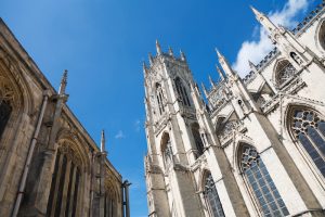
The Roman fort of Eboracum was established in 71 AD eventually covering 52 acres. We found ourselves in front of the Minster looking at the Column Principia, which was excavated from below the Minster and marks the centre of the Roman fort. The settlement was the centre of the Roman Empire Inferior (the word had a different meaning at the time of ‘Lower’ as of secondary importance only to Rome itself). Several Roman Emperors lived here for a time and Constantine was proclaimed Emperor at the fort when his father died while in residence, hence the statue of Emperor Constantine, which we were looking at.
By 866AD the Vikings had conquered Northern England and set up the trading centre of Jorvik on the footprint of the Roman fort. When a sweet factory was demolished in 1976, a horde of Viking artifacts was discovered underneath which led to the setting up of the Jorvik centre in 1984 to showcase the Viking way of life.
After the battle of Hastings William the Conqueror moved north to quell rebellions and regain control of the settlement, which was given the anglicized name of York. He in turn built his Motte and Bailey castle over the original Roman and Viking remains and extended the walls. The first stone Minster was built in 1080 and its remains can still be seen underneath the existing building. Land surrounding the area was parceled up and given to the Norman Barons, some of which was then handed down to religious communities. The Benedictines built the church of St. Mary’s Abbey whose ruins we saw in the grounds of the existing museum. Altogether 26 other monastic communities were established around the city contributing to York becoming a boom town – until the dissolution of the monasteries under Henry VIII, after which the city declined.
Then York espoused the cause of Charles I in the civil war and in 1644 was besieged by Parliamentarians. It  wasn’t until the 1730’s when the Georgians rediscovered the charms of the city that things began to improve. We walked past the Middlethwaite Terrace, the Mansion House and the Assembly Rooms all fine examples of Georgian architecture.
The early 1800’s saw York eclipsed by other northern cities in the Industrial Revolution – there were no large factories as the authorities controlled new development and stifled entrepreneurs. It was the coming of the railway in 1840 which started an upturn. The first station was built inside the city walls and we could see the holes that were punched through the walls to allow access for the trains. As York became a very important railway hub a larger modern station was built outside the walls in 1878, at the time the largest railway station in the world.
The chocolate industry became established in the mid 19C by Joseph Rowntree who employed as apprentices Cadbury and Fry – they were all Quakers. We saw Leethams Mill which was used as Rowntree’s warehouse from 1860 until 1960. We were very entertained by the information about the Kit Kat bar, first made in 1935, that 546 fingers are eaten worldwide every second! Another Quaker chocolate business was started by Joseph Terry and as we looked at the factory clocktower of 1920 we were reminded that this image is on all the After Eight chocolate boxes.
The population of York is now 200,000 of which 30% are employed by the tourism and retail sector. There are future plans to develop a large brownfield site, where the old railway buildings were, into a huge cultural and retail sector, incorporating the existing railway museum.
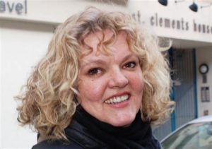 Sarah Cowling was a most interesting and informative guide and her use of both old and modern maps was so helpful in understanding the historical development of the city throughout the ages.
Wendy Allan